Features
A quick tour of what Pelorus Nav does, grouped by what you'd use it for. The links lead to the parts of this guide that cover each feature in detail.
Charts & display
Pelorus Nav draws official NOAA electronic charts (ENC) as vector charts, with the standard IHO S-52 symbology used by commercial chartplotters. The charts cover US coastal waters, the Great Lakes, Puerto Rico and the US Virgin Islands, and Hawaii (Alaska isn't covered).
- Official NOAA vector charts in 15 downloadable regions — see The Chart Display and downloading charts.
- Kept current — NOAA's chart updates are checked nightly, and downloaded regions show Update available when a newer version is published.
- Multi-scale quilting — charts of different scales blend into one seamless chart as you zoom, with more detail appearing as you zoom in (detail levels).
- Day, Dusk, Night, and E-ink themes using the official S-52 color palettes (display themes).
- Adjustable detail level, optional layer groups, and chart text and icon size.
- Light sectors and a charted currents layer, including the Gulf Stream arrows printed on offshore charts (layers).
- Depth shading set to your boat's draft, with a safety contour and an optional white deep-water look (settings).
- Offline street basemap for land detail near shore (downloading charts).
- Follow, course-up, and north-up modes, with a look-ahead offset that shows more water ahead of the boat (chart modes).
- Magnetic or true bearings throughout the app (settings).
- Your own raster charts — satellite imagery or scanned charts loaded as PMTiles files; MBTiles and BSB/KAP charts can be converted on a desktop computer first (Your Own Charts).
Chart tools
Tap the chart to find out what's there, find a place by name, or measure and plot the way you would on paper.
- Tap to identify any charted object — buoy, light, wreck, depth area — and see its attributes (identifying features).
- Place search by name — harbors, islands, buoys, lights — working offline for downloaded regions (finding places).
- Go to coordinates from search or the context menu (context menu).
- Measure range and bearing along a path (context menu).
- Traditional plotting — fixes, DR, EP, and running fixes; bearing lines (LOPs), distance arcs, current arrows, and notes (Traditional Plotting).
Navigation
Plan routes on a big screen or on the boat, then follow them leg by leg with live steering guidance.
- Routes and waypoints — tap to build a route, drag to edit, undo, snap to existing waypoints, reverse, and extend from either end (editing a route).
- Folders and bulk selection for routes, waypoints, and tracks (organizing with folders).
- Waypoint symbols in the shapes and colors Garmin and ActiveCaptain use, so imported marks keep their coding (symbols).
- Navigate to any point — a waypoint, or anywhere you long-press on the chart (context menu).
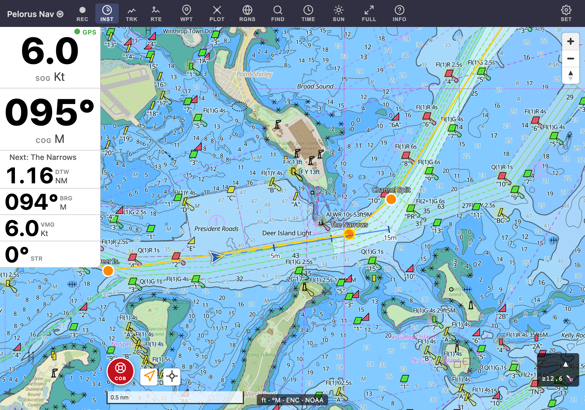
- Auto-advancing legs with an arrival beep, and joining a route partway along (following a route).
- Navigation instruments — SOG, COG, VMG, bearing, steer-to, distance to waypoint and destination, time to go, and ETA (following a route).
- Projected course line ahead of the vessel, with time ticks (following a route).
Safety
- Crew overboard (COB) button — press and hold to drop a mark and start navigating back to it (the main screen).
- Anchor watch (experimental) — a watch circle around your anchor with a drag alarm, GPS-lost alarm, and tide-aware scope. In the Android app it keeps watching with the screen off; in a browser it works only while the page stays open with the screen on; it isn't yet available in the iOS app (Anchor Watch).
- GPS warnings — a NO GPS badge when the fix goes stale, with speed and course blanked rather than left showing old values (instruments).
- Touchscreen lock so spray and stray taps can't change anything under way (settings).
Tracks
Record every outing, then replay it and see how it went.
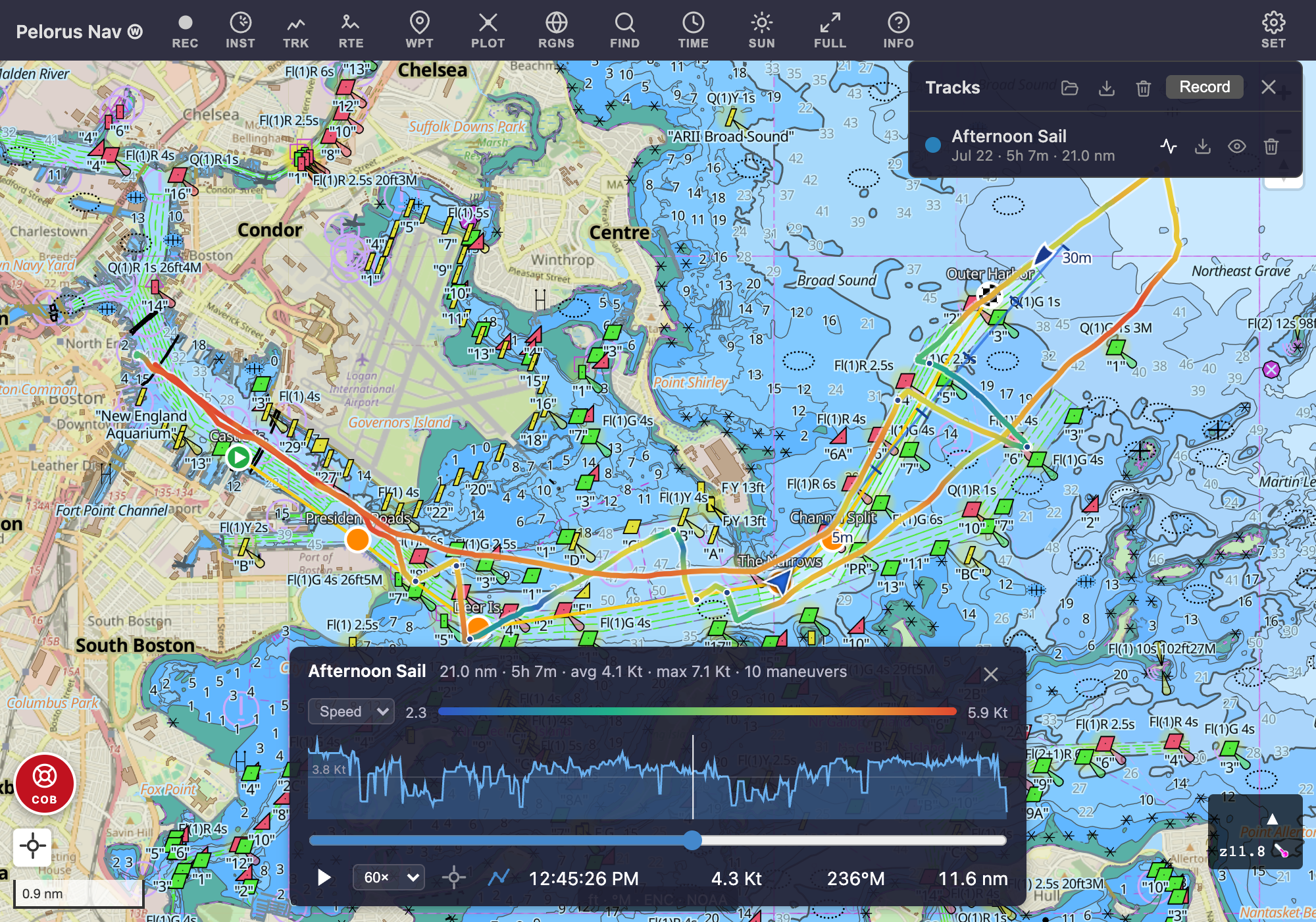
- Track recording that survives app restarts, and continues in the background with the screen off in the Android and iOS apps (recording).
- Track Viewer with a speed-colored track and a speed-profile chart (the Track Viewer).
- Playback at up to hundreds of times real speed.
- Tack and jibe detection, with each maneuver marked on the chart.
- Stats for any stretch — select part of the speed chart for its distance, time, and average and max speed.
- Route preview with time estimates at a planning speed (the Routes panel).
- GPX import and export for routes, waypoints, and tracks, with re-imports updating rather than duplicating (export and import).
Tides, wind & sun
Predicted conditions drawn right on the chart, up to 48 hours ahead.
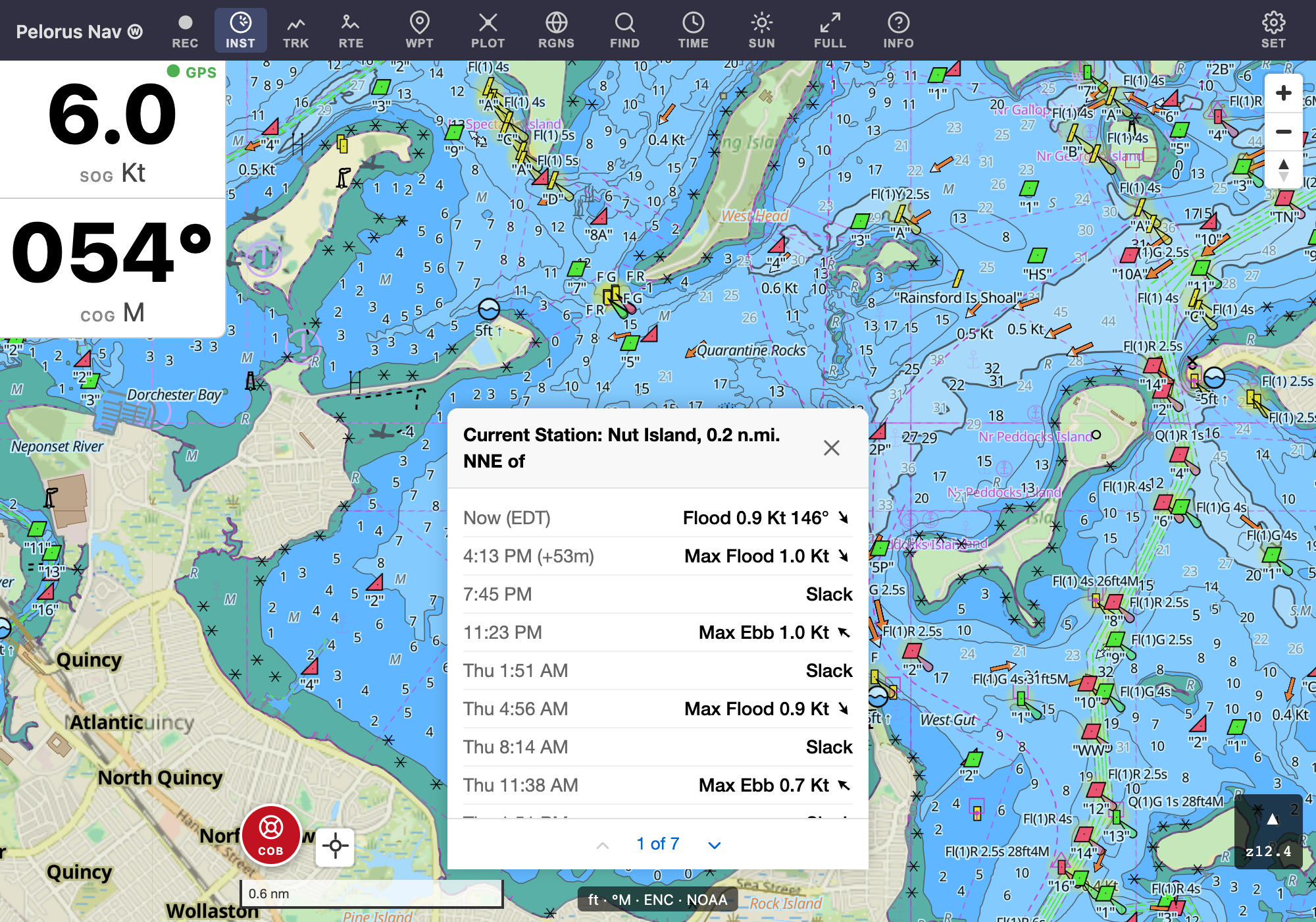
- Tide and current predictions from NOAA stations, computed on the device so they work offline (tides & currents).
- Nearest tide station to your vessel in one tap (the nearest tide station).
- 48-hour time bar to scrub tides, currents, and wind forward (the time bar).
- Wind forecast barbs — needs an internet connection (wind).
- Sunrise, sunset, and twilight times for the week (sun & twilight).
Offline & downloads
Once a region is downloaded, charts, tides, and place search work with no signal at all.
- Downloadable chart regions, each with its size shown before you start (downloading charts).
- Queued, resumable downloads — interrupted downloads continue from where they stopped, and on Android they keep going in the background.
- Chart update notices — the app tells you when newer charts are ready for regions you've downloaded, and Update All refreshes several at once.
GPS & devices
- Device GPS — the phone's or tablet's own receiver.
- Bluetooth GPS — Classic NMEA receivers such as the Garmin GLO 2 (in the Android app), and Bluetooth LE receivers.
- USB serial GPS in browsers that support Web Serial, such as Chrome and Edge on a computer.
- Signal K (experimental) — the boat's own GPS and heading from a Signal K server (Signal K).
- Built-in simulator that sails a boat around Boston Harbor, for exploring the app ashore (settings).
- Battery warning for Bluetooth GPS receivers that report their battery level, such as the Dual XGPS150A.
Everyday conveniences
- Volume-key zoom on Android (settings).
- Keep screen on while the GPS is active.
- Auto-recenter when idle — open panels close and the chart returns to your vessel after a minute (chart modes).
- In-app bug reports — INFO → Report a Bug… sends a description along with the diagnostics needed to track the problem down.
Platforms & principles
- Web app at pelorus-nav.com/app — any modern browser, installable to the home screen for full-screen offline use.
- Android app in beta, through the Play Store's closed testing or as the signed APK from GitHub releases.
- iPhone and iPad app in beta through TestFlight.
- Free and open source — MIT-licensed on GitHub.
- No account and no tracking — your routes, tracks, and position stay on your device.
See Where to get it for installation details.