
Traditional Plotting
In a modern chartplotter there is rarely a need for the traditional plotting tools of pencil, parallel rules, and dividers. But the old ways are worth keeping alive — they're satisfying, they build the skills you'll want if the electronics ever quit, and they're genuinely useful on longer passages and when planning. So Pelorus Nav has a set of traditional plotting tools built in.
Open them with PLOT in the top bar, or place a single element from the chart context menu's Plot ▸ submenu. The toolbar appears at the top of the chart:

Pick a tool, then tap the chart to place its element. Tapping an existing element selects it for editing — its numbers (bearing, distance, radius, label, text) appear as fields in the toolbar's second row, along with Delete. Everything you plot is saved with the chart and stays visible after Done closes the toolbar; Clear wipes the sheet when the exercise is over.
Position symbols
The four position symbols are the standard ones you'd pencil on a paper chart, each with a time label:
 Fix — a position you're sure of: visual or radar fix, or a confirmed GPS position you want on the record.
 DR (dead reckoning) — where you should be, projected from your last fix along your course at your speed, ignoring current and leeway.
 EP (estimated position) — a DR corrected by whatever partial information you have: one line of position, or known set and drift.
 R.Fix (running fix) — a fix from two bearings of the same object taken at different times, the first line of position advanced along your run.
Lines, arcs, and notes
- Brg places a bearing line — a line of position through a point at a bearing you type (magnetic or true, e.g.
339M). Sight a lighthouse over your hand-bearing compass, tap the light, enter the bearing: you're somewhere on that line. - Line ▾ offers a free line between two points, a Brg/Dist line (a line from a point at a typed bearing and distance), and a current arrow — the chevroned set-and-drift vector of classic chartwork.
- Arc draws a distance arc — a circle of position from a radar range or a vertical-sextant-angle distance, or a keep-clear ring around a hazard.
- Text drops a free note anywhere on the chart.
Lines and arcs label themselves with their computed magnetic bearing and distance, so a plotted line doubles as a measurement.
A worked example
Here's a half hour of classic chartwork in President Roads — a 1400 fix, a DR track run out at 5 knots, and at 1430 a bearing of Deer Island Light giving a line of position; where the LOP disagrees with the 1430 DR, an EP square marks the better answer. A 0.4 NM danger arc rings the light, and a current arrow with a note records the ebb the plot needs to explain the difference:
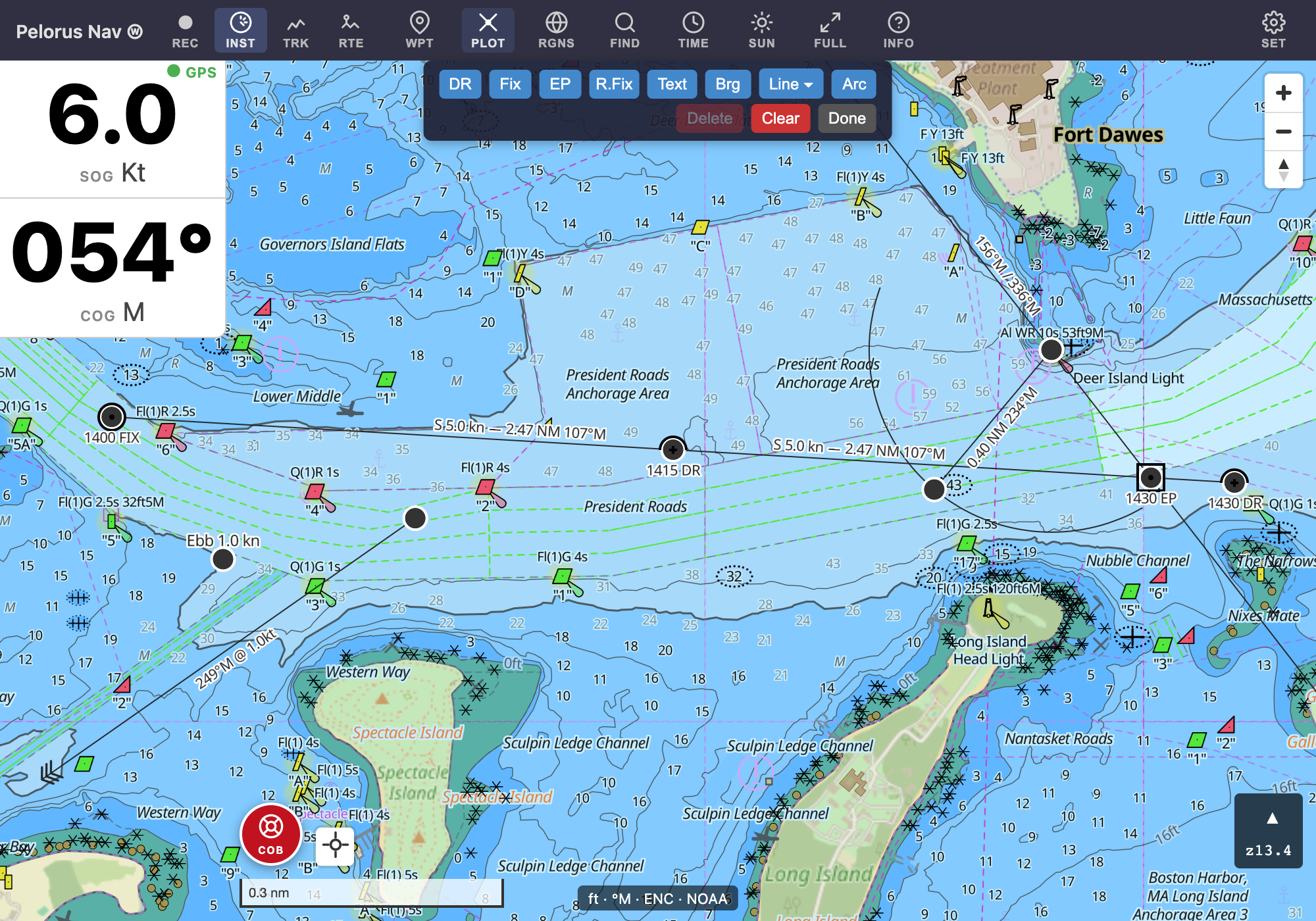
Every element here was placed with the toolbar in under a minute — no parallel rules required, though we won't tell anyone if you check it against the paper chart afterward.